Aerial Video Survey Program
at the University of New Orleans
| Introduction |
| Surveys Completed |
| Survey Methods |
| Advantages |
| Applications |
| Sample movie |
| Professional Home Page |
| Home Page |
Note: I have a gratis appointment with UNO, but aerial surveys are no longer a regular event. The best example of this technology was completed in 2007 as part of the Louisana Department of Natural Resources Barrier Island Comprehensive Monitoring Progam (BICM).
Introduction
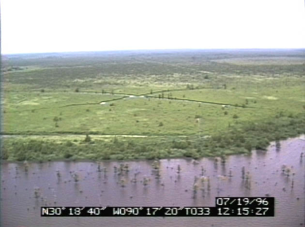
The use of aerial video surveys for coastal zone management, coastal research, and oil spill planning and response applications has increased greatly do to the immense wealth of information contained in this database. Oblique aerial video surveys can systematically inventory large coastal areas rapidly and can be viewed immediately after acquisition to support emergency response operations. The most recent surveys have been organized and indexed onto DVDs for ease of use. Internet access is being planned for the future. Aerial video imagery has the resolution to document sediment type, coastal landforms, oiling character and distribution, habitat type and other pertinent environmental information, all linked to navigational data. Global Positioning System (GPS) data is recorded directly onto the video image and downloaded for later analysis and GIS use. The audio portion of the data contains narration by a coastal geologist or local technical expert to assure accurate commentary.
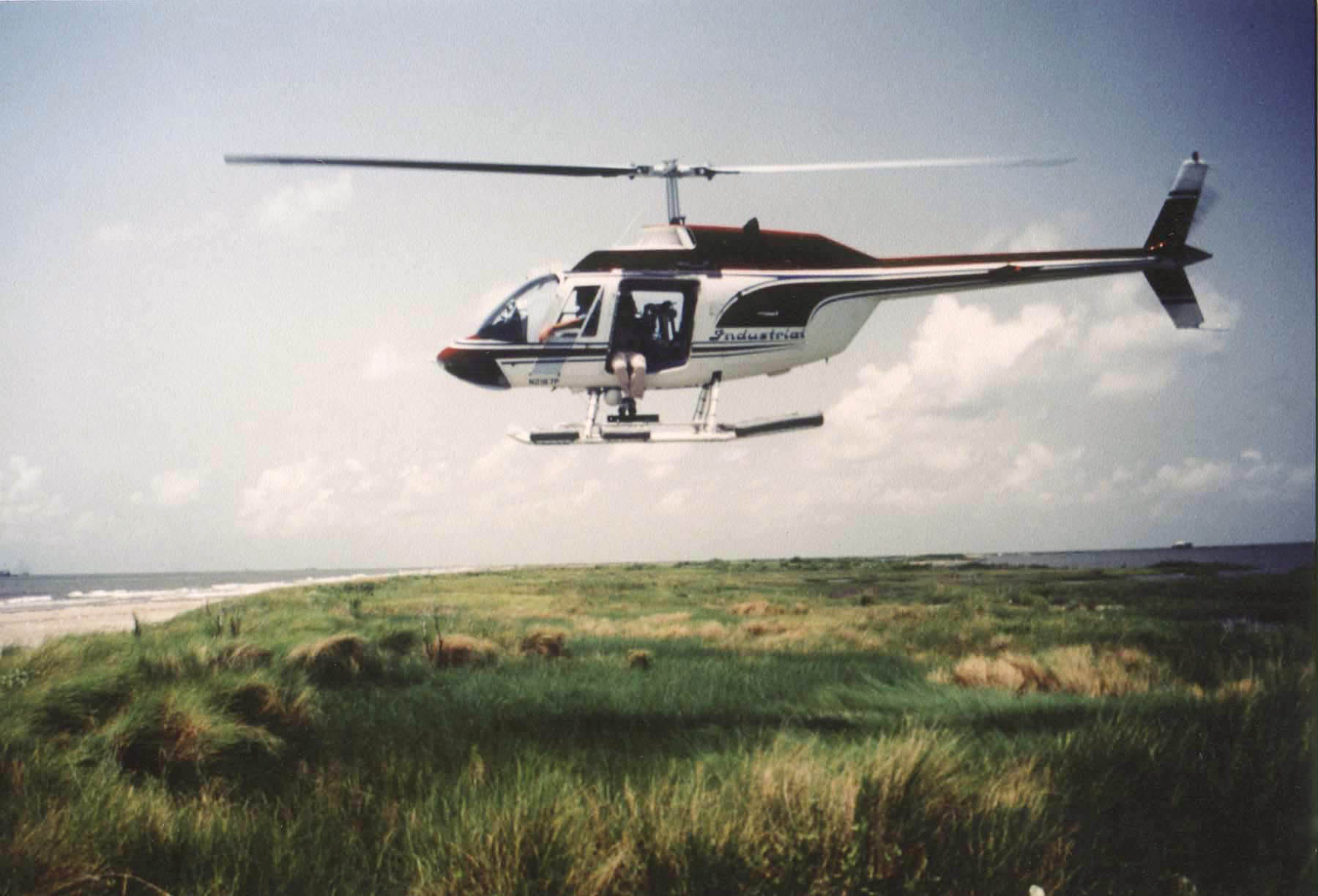
The staff of the Aerial Video Survey Program (AVSP) have more than 30 years of experience in coastal research and in aerial video survey experience in the Gulf of Mexico.Surveys Completed
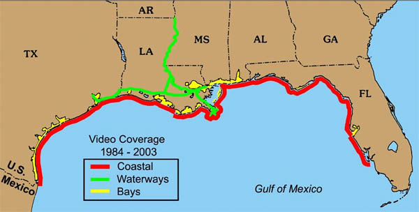
Aerial Videotape Survey of:
1) Coastal Louisiana - 1984.
2) Louisiana Barrier Shorelines - 1985.
3) the Hurricane Danny Impact Zone - 1985
4) the Hurricane Elena Impact Zone - 1985
5) the Hurricane Juan Impact Zone - 1985
6) of Coastal Louisiana - 1986
7) Coastal Louisiana - 1987
8) Coastal Louisiana - 1988
9) the Hurricanes Florence and Gilbert Impact Zones - 1988
10) Coastal Louisiana, Mississippi and part of Alabama - 1989
11) Coastal Louisiana - 1990
12) Coastal Louisiana, Mississippi, and Alabama - 1991
13) Coastal Texas and Louisiana - 1992
14) the Hurricane Andrew Impact Zone - 1992
15) the Northern Gulf of Mexico - 1993
16) the Mississippi River: Baton Rouge to Venice, Louisiana - 1994
17) Coastal Louisiana - 1994
18) the Intracoastal Waterway: Baton Rouge to New Orleans to Houston - 1995
19) the Hurricane Opal Impact Zone - 1995
20) the Northern Gulf of Mexico: Brownsville, Texas to Naples, Florida - 1996
21) the Mississippi River: Baton Rouge, Louisiana to the Gulf of Mexico - 1996
22) the Hurricane Georges Impact Zone - 1998
23) the Laguna Madre and Baffin Bay, Texas - 1999
24) the Northern Gulf of Mexico: Louisiana to Florida - 1999
25) Coastal Louisiana - 2001
26) the Mississippi River from Baton Rouge to Arkansas - 2003
27) Coastal Louisiana - 2006/2007
Survey Methods
The surveys were usually flown at an altitude of 200-500 ft and a speed of 40-60 knots parallel to the shoreline to provide oblique imagery of the shore or feature. Photography (historically 35 mm slides; more recently digital stills) were taken in conjunction with the video. The cameras were operated on the left side of the helicopter so that all shorelines were recorded from left to right, and the image was always to the left of the flight path. This corresponded to the controls on most video players so that the fast-forward and reverse buttons speeds the viewer virtually in the direction of the arrows.
Advantages of aerial video imagery
For our use, “oblique”imagery, means a video angle near- perpendicular to the line of flight, keeping near and far features in frame. Usually, the frame includes features from the horizon to the nearshore area. This type of video is more diversely utilized by a variety of agencies and researchers, because it lends itself to more qualitative and general uses, and is more comfortable to view. The oblique angle provides a wide reference to surrounding areas and conditions and makes an ideal source for finding reference points for field related activities. In an erosive or highly changing landscape, the oblique angle provides a multitude of reference points all the way to the horizon when shoreline features are altered drastically by time or storms. Oblique video imagery contains a wealth of qualitative information in a continuous record of existing conditions: shoreline types, access avenues, vegetative cover, habitat types, health of the system, land use, tidal inlets, beach conditions, erosion types, overwash types, etc.
The aerial view point shows the relationship of surrounding features, including those on both sides of a shore-parallel levee or line of trees. Ground features not evident on maps can be picked out for accessing a particular area, such as dirt track access to the shoreline, a field or parking lot that could be used as a staging area, unmarked waterways, nearshore posts that can be used to tie boats or booms, etc. The continuous nature and resolution of video insures that nothing is overlooked. The oblique angle and continuous movement or change in perspective produces a 3-D effect, accentuating relief and the position of features for a better understanding of the landscape. Some features that tend to be hidden can be picked out from behind a moving screen of objects. This 3-D feature is missing from inline or vertical video. When GPS data is incorporated with the video data, GPS data gives a constant reference to every image.
Digital access by interactive DVDs increases the ease of use of this valuable resource. The 2001 Coastal Louisiana Survey as well as the lower Mississippi River 1996 & 2003 are available at cost of production. The all-digital 2006/2007 still imagery is available here, or through LDNR. The video imagery is available by ordering DVDs at cost. Note: the shoreline continues to change, by natural and artificial evcnts, so no imagery can be completely up to date.
Applications
The aerial video survey data form an extensive data set for a variety of uses. The application of aerial video surveys includes:
- Support oil spill planning, training, and response activities.
- Monitor coastal erosion and wetland loss.
- Document storm effects.
- Provide pre-event baseline documentation for before/after comparisons.
- Document restoration or protection project performance.
- Monitor restoration projects on barrier islands and in wetlands.
- Strategy planning along rivers, navigational channels, shorelines, barrier islands, wetlands, and marshes.
- Documentation of resources at risk.
- Obtain updated visual records on the status of coastal structures.
- Documentation of oil spill conditions on the water and along shorelines..
- Documentation of storm damage for restoration claims.
- Environmental Sensitivity Index mapping.
- Shoreline and habitat type mapping over large areas.
- Inventory derelict structures.